
Showing posts with label ***SOLENT EAST (NORTH)***. Show all posts
Showing posts with label ***SOLENT EAST (NORTH)***. Show all posts
Sunday, 18 May 2008
Chichester Harbour - Itchenor to East Head
View Larger Map
Grid Refs
Itchenor SU 799 014 GB
East Head SZ 769 992
Pilsey Island SU 771 007
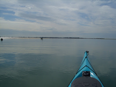
This short stretch of Chichester Harbour is of interest because of the strong tides present. If to your advantage, stay in the deep water following the channel marks. If going against the flow, tuck close in shore to be spared the worst of it.
Itchenor is described elsewhere in the Solent Kayak Pages, under the label Chichester Harbour.
Pilsey Island is a small island is at the south west corner of the mouth of the Thorney Channel. Landing is permitted here and the eastern side of it is a popular anchorage for yachts. Landing is permitted on the shingle beach and it would make a good stop for a meal or coffee stop. Information boards tell about the island.
East Head is a sandy beach and nature reserve, that forms a spit on the eastern side of the harbour mouth. It is also a popular anchorage offering shelter in south / west winds and seems to be a favoured stretch of beach for a Sunday stroll.
Access / Put-ins:
Itchenor hard gives access at all states of tide. There are also plenty of other access points around the harbour which you are likely to visit in the same paddle.
Nature:
Chichester Harbour is home to enormous numbers of wildfowl.
History:
Itchenor was a ship building village, dating back to Tudor times.
Waterside Pubs:
None.
Hazards:
Strong tides in Chichester Channel, make for a surprising seaway when the wind is up and offer good practice for ferry gliding.
Wednesday, 23 April 2008
Solent Crossing
Gosport to Ryde / Wootton Creek
View Larger Map
Grid ref
Stokes Bay (GAFIRS) SZ 599 979
Ryde Pier SZ 592 936
Wootton Creek Entrance SZ 557 932
This route across the Solent is from Stokes Bay (Gosport) to Ryde, Isle of Wight and then along the coast to Wootton Creek, with the return passage to Stokes Bay
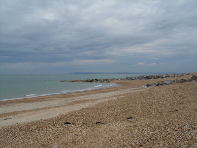
Stokes Bay
 Stokes Bay is a wide shingle beach extending for about a mile between Browndown Point and Gilkicker Point. I selected a starting point at GAFIRS car park - Gosport And Fareham Inshore Rescue. There are several pay & display car parks along Stokes Bay and any would do. All are 60 pence per hour, or £3.60 for the day. The beach is quite steeply shelving and this needs to be considered if the wind has any south in it - waves break dramatically at times.
The Route
The route (about 3.5 miles)crosses both the north and south (main) shipping lanes from the eastern Solent to Southampton. It also crossed the path of the Wight Link car ferry that travels from Portsmouth to Wootton Creek (Fishbourne). The north channel is fairly minor and only used by smaller cargo ships. The main channel on the southern side of the Solent carries the largest ships in the Solent. This route does not cross the paths of either the high speed passenger ferry to Ryde or the hovercraft. Ryde lies almost due south of Stokes Bay, but an allowance must be made for the tide which generally sets at ninety degrees to the route, east or west depending on the tide flow at the time. At a typical gentle speed of three miles per hour, allow for one hour of tide. The crossing should take an hour or less in good conditions and the same for the return leg. There are no navigation marks on the route, although the return leg will pass near to the Mother Bank buoy on the southern side of the main channel. There is a period of slack water here about two hours before high water at Portsmouth.
The Isle of Wight Coast
 The part of the coast visited on this route includes large expanses of sand bank, tree lined beaches (possibly private) and rocky outcrops. Ryde Pier marks your arrival on the Isle of Wight. The pier was extended through the 1800s to 681m. Staying west of it avoids the ferry and hovercraft. The flat expanse of sand is quickly covered by the tide so it is worth pulling kayaks well clear of the water edge on a flooding tide.
 The coast between Ryde and Wootton Creek appears to be privately owned, but a very pretty tree lined beach greets the eye. A few rocky outcrops separate you from Wootton Creek, about 1.5 miles west of Ryde.
Wootton Creek is home to the car ferry and this needs to be avoided, although the channel is plainly seen. Inside the mouth lies a tidal pond stretching in land about half a mile to Wootton itself, offering a waterside pub and shop facilities.
Access / Put-ins:
Stokes Bay access is described above.
On the Isle of Wight, access can be had at Ryde or Wootton Creek, though it will involved a significant portage from public car parks on nearby roads.
Nature:
In the summer months, dolphins may be sighted, as a schooling mackerel.
History:
Ryde Pier has a history all of its own.
Waterside Pubs:
Waterside cafes at Stokes Bay and a pub at the top of Wootton Creek.
Hazards:
Wind and tide can make the Solent an unforgiving place. The sheer volume of water craft doubles the danger. A good look out needs to be maintained. It is advisable to carry a GPS to assist as a mist or haze is usually present in the summer months. Ryde can be easily identified by the to spires visible on the hill behind the town, but on the northern side of the Solent, the coast appears bland to the eye and it is difficult to identify any land marks.
View Larger Map
Grid ref
Stokes Bay (GAFIRS) SZ 599 979
Ryde Pier SZ 592 936
Wootton Creek Entrance SZ 557 932
This route across the Solent is from Stokes Bay (Gosport) to Ryde, Isle of Wight and then along the coast to Wootton Creek, with the return passage to Stokes Bay
Stokes Bay
 Stokes Bay is a wide shingle beach extending for about a mile between Browndown Point and Gilkicker Point. I selected a starting point at GAFIRS car park - Gosport And Fareham Inshore Rescue. There are several pay & display car parks along Stokes Bay and any would do. All are 60 pence per hour, or £3.60 for the day. The beach is quite steeply shelving and this needs to be considered if the wind has any south in it - waves break dramatically at times.
The Route
The route (about 3.5 miles)crosses both the north and south (main) shipping lanes from the eastern Solent to Southampton. It also crossed the path of the Wight Link car ferry that travels from Portsmouth to Wootton Creek (Fishbourne). The north channel is fairly minor and only used by smaller cargo ships. The main channel on the southern side of the Solent carries the largest ships in the Solent. This route does not cross the paths of either the high speed passenger ferry to Ryde or the hovercraft. Ryde lies almost due south of Stokes Bay, but an allowance must be made for the tide which generally sets at ninety degrees to the route, east or west depending on the tide flow at the time. At a typical gentle speed of three miles per hour, allow for one hour of tide. The crossing should take an hour or less in good conditions and the same for the return leg. There are no navigation marks on the route, although the return leg will pass near to the Mother Bank buoy on the southern side of the main channel. There is a period of slack water here about two hours before high water at Portsmouth.
The Isle of Wight Coast
 The part of the coast visited on this route includes large expanses of sand bank, tree lined beaches (possibly private) and rocky outcrops. Ryde Pier marks your arrival on the Isle of Wight. The pier was extended through the 1800s to 681m. Staying west of it avoids the ferry and hovercraft. The flat expanse of sand is quickly covered by the tide so it is worth pulling kayaks well clear of the water edge on a flooding tide.
 The coast between Ryde and Wootton Creek appears to be privately owned, but a very pretty tree lined beach greets the eye. A few rocky outcrops separate you from Wootton Creek, about 1.5 miles west of Ryde.
Wootton Creek is home to the car ferry and this needs to be avoided, although the channel is plainly seen. Inside the mouth lies a tidal pond stretching in land about half a mile to Wootton itself, offering a waterside pub and shop facilities.
Access / Put-ins:
Stokes Bay access is described above.
On the Isle of Wight, access can be had at Ryde or Wootton Creek, though it will involved a significant portage from public car parks on nearby roads.
Nature:
In the summer months, dolphins may be sighted, as a schooling mackerel.
History:
Ryde Pier has a history all of its own.
Waterside Pubs:
Waterside cafes at Stokes Bay and a pub at the top of Wootton Creek.
Hazards:
Wind and tide can make the Solent an unforgiving place. The sheer volume of water craft doubles the danger. A good look out needs to be maintained. It is advisable to carry a GPS to assist as a mist or haze is usually present in the summer months. Ryde can be easily identified by the to spires visible on the hill behind the town, but on the northern side of the Solent, the coast appears bland to the eye and it is difficult to identify any land marks.
Saturday, 5 January 2008
Solent Crossing
View Larger Map
Grid ref
Southsea SZ 657 982
Nettlestone Point SZ 630 917
Priory Bay SZ 635 901
This route across the Solent is from Southsea (Portsmouth) to Nettlestone Point near Seaview, Isle of Wight.
Southsea
Southsea sea front is a long shingle beach extending for several miles between Portsmouth and Langstone Harbours. I selected a starting point just east of South Parade Pier, where the road (with on street pay & display parking) passes close to the water edge.

The Route
The route follows a line of submerged blocks (a sea defence for Portsmouth Harbour) south to Horse Sand Fort, a large disused circular fort still in the ownership of the Ministry of Defence. The blocks are a charted hazard to all shipping, both commercial and pleasure so afford good protection for paddlers over this two mile stretch of the route. From here, the route turns south west across the main shipping channel that carries shipping to Portsmouth and Southampton docks, to No Mans Land Fort, a similar fortress but converted in to an elaborate residence with tennis court,swimming pool and heli-pad. Reaching this fort marks the other side of the shipping channel and relative safety.
The Isle of Wight Coast
Continuing broadly south west takes you to Nettlestone Point, a rocky outcrop at the small village of Seaview. West of this point is two miles of sandy beach leading to Ryde. East of the headland leads to Seagrove Bay and further south east, Priory Bay and Bembridge Harbour.
Priory Bay is a beautiful sandy beach at the foot of a tree lined bank, making it very sheltered in a soutwesterly wind. The headlands at either end are rocky.

Bembridge Harbour is a picturesque haven for pleasure boats, with water side cafes either side of the harbour entrance.
Seaview is an attractive small coastal village with a waterfront cafe at the centre of Seagrive Bay.
Access / Put-ins:
The promenade at Southsea mostly follows the coast closely, with on street pay & display parking.
On the Isle of Wight, access can be had at Bembridge, Seaview and Ryde.
Nature:
In the summer months, dolphins are being sighted mroe frequently.
History:
The sea forts, dating from the 1860s onwards are the most significant historical feature at this end of the Solent. There are four, and this route passes by two of them and offers views of the smallest, St Helens Fort.
Waterside Pubs:
Waterside cafes at Bembridge Harbour, Seaview and at Southsea near the pier.
Hazards:
At 4.5 nautical miles, this route is possibly amongst the longest to cross the Solent and as such has a few hazard spots, but lots of relatively safe water.
Paddlers should allow for the set and strength of the tide and bear in mind that it flows at a faster rate in the shipping channel and on the Island side. The wind strength and direction can have a large effect too, on different sides of the Solent.
The tidal streams in the immediate vacinity of the sea forts are unusual, with distinct eddies and these areas can have very confused winds and sea.
Shipping is an obvious hazard, but bear mind that it will take at least 15 minutes in good conditions to cross the shipping channel and a lot of ships have a limited view directly ahead of them, are deceptively fast and restricted by their draft. If in doubt, stay near one of the forts for safety.
Also, a small change in the weather can have a dramatic effect on the sea conditions, especially in an easterly wind.
Thursday, 19 July 2007
Circumnavigating Hayling Island
View Larger Map
Langstone Harbour entrance SZ 687 990
Chichester Harbour entrance SZ 753 980
Langstone Bridge SU 719 046
In planning a circumnavigation of Hayling Island, a paddler should aim to take advantage of the tides. In the Solent, the tide sets eastwards from two hours before low water, to four hours after, before reversing its direction. On Spring tides, the flow can make a huge difference to passage times. There is slack water around the turn of the tide flow, usually lasting up to an hour. Allow four hours, or more in less than favourable conditions. My route is 15.2 statute miles (13.2 nautical miles). Beware that arriving at Hayling Bridge at low water on spring tides will mean you will be out of the kayak walking through very soft mud.
Langstone Harbour
In my trip, I set off from Tudor Sailing Club in the north west corner of Langstone Harbour, as I happen to be a member. On a flooding tide, an hour after low water, the harbour is reduced to mud, sand and narrow channels. The weather conditions for this trip were ideal, with very light southerly winds and a slight sea. Two of the resident seals greeted me shortly after setting off, but were camera shy. Further down in the harbour entrance, if you tuck yourself in close on either side of the entrance, you can escape the worst of the tide when it is against you. Unfortunately, you can never escape the inevitable jet skis.

Turing left as you emerge from the harbour, if you have timed it right, you can pass through a very shallow passage, avoiding a long paddle out and around the enormous East Winner sand bank. Be careful in rough weather - my last kayak was holed several times by impromptu groundings here, not by me I hasten to add!
Langstone Harbour to Chichester Harbour ~ Hayling Island Seafront

Ahead of you lies 4 miles of shingle beach, the most exposed in the Solent and hence very popular for wind surfers. Not today though. Once past the sand dunes, you paddle parallel to a colourful row of beach huts, atop a sloping sea wall. A white building on the beach comes in to view - a pub called The Inn on the Beach (very original). Next up is an unusual domed tent, marking the fun fair. The beach huts continue, with large houses behind overlooking the sea. Further along, a white square tower comes in view. It is a coast guard look out tower and as you pass it, you realise that it is just the end of a building, the rest being unpainted. The sea wall continues, with many groins jutting out into the sea and more beach front residences behind. You now have only a mile to go before you arrive at the entrance to Chichester Harbour. An odd structure, lying offshore that has been visible for some time, comes clearly into view - the Chichester Bar Beacon. It marks the West Pole Spit that is a similar hazard to the East Winner at Langstone. The sand bar has shifted however so the mark is no longer satisfactory for larger craft. Beware of the tides and difficult seaway that can occur near the harbour entrance.
At the lower states of the tide, the entrance on the Hayling side offers a nice sandy beach, just right for a lunch landing, which is exactly what I did.
The view across to the Isle of Wight.
Chichester Harbour
The harbour mouth, across to East Head.

After a thirty minute break, I was keen to get paddling again. The harbour entrance passed by very quickly, at 6.2 knots in fact...

The view up the Emsworth Channel is typical of much of the Solent - many yachts laying to their moorings. My passage up the eastern side of Hayling Island followed the mud banks, which were still visible. At high water, the small inlets (known as Rythes in Hayling) would provide an amusing hour or so of paddling. The channel continues northward, eventually splitting in two. Emsworth is visible ahead, however to complete the circumnavigation, take the left fork, passing Northney Marina. The channel dries on low water springs. The Hayling Bridge comes in view, with an assortment of buildings on the main land side - Langstone village.


At the right hand end of the buildings, is the foot of an old windmill.
At the left hand end is the Ship Inn public house, accessible directly from the water for about half the tide.
 Langstone Harbour again
 Paddling under the road bridge takes you back in to Langstone Harbour. A small but brisk weir effect can be found at low water springs when the tide begins to rise again. You can just paddle through it. The row of blocks in immediately front of you are the remains of the the Havant to Hayling rail way line, known as the Hayling Billy. Look carefully on the spur of land on the Hayling side. You can still see an old rail signal post. Depending on your start point, you should either follow the channel markers back tot he harbour entrance, or in my case, I picked my way through the small group of RSPB protected islands back to my start point, now with sufficient water in the harbour to make it possible.
The view back across the harbour to Hayling Bridge.

Friday, 6 July 2007
Browndown Point to Portsmouth Harbour
LINK TO GOOGLE MAP
Continuing east from Browndown Point, the barren shingle beach provides peace and quiet. The first sign of habitation appears after half a mile as you enter Stokes Bay - a beach cafe. The bay continues eastwards, sweeping round in an attractive arc. The next building is the Pebble Beach Cafe, followed by Stokes Bay Sailing Club and GAFIRS - Gosport and Fareham Inshore Rescue Service. The next headland is reached soon after - Gilkicker Point. The tide can kick up a bit here. Turning the corner, the beach soon runs out as you reach Fort Monkton, an active military base. Landing here is strictly prohibited and you are unlikely to receive any sort of welcome. The beach is replaced with a hostile concrete sea defence known locally as the Hot Walls. The old red brick buildings visible behind are Haslar Hospital and Fort Blockhouse, again all owned by the MOD. You couldn't land here if you wanted to. As you arrive at Portsmouth Harbour entrance, keep an eye open for leisure and commercial shipping. You will find yourself at the Small Boat channel, which is fine if you want to enter Portsmouth Harbour.
To continue eastwards, you will need to stay slightly offshore and follow the channel buoys until clear of the harbour entrance before crossing. Beware of the tides near the harbour entrance, especially on Springs.
Access / Put-ins:
Stokes Bay beach and slipway.
Portsmouth Harbour at Haslar Lake or The Hard / The Camber.
Nature:
Not a lot along this stretch of coast.
History:
Haslar Hospital and Fort Blockhouse on view.
Waterside Pubs:
Pebble Beach Cafe is licensed.
Hazards:
Occasional live firing at Browndown, no landing places east of Gilkicker Point, tides and shipping at Portsmouth Harbour entrance.
Bosham to Dell Quay
View Larger Map
Bosham SU 803 038 GB
Dell Quay SU 835 028 GB
Itchenor SU 799 014 GB
Chichester Harbour offers many pleasant paddling opportunities as it has several different estuaries, miles of coast line and masses of wildlife.
BOSHAM
Bosham is a delightful village, situated towards the head of Bosham Creek. It was here that King Canute reputedly ordered the tide to recede. The quay here dries but offers access at all states of tide. The coastal road, WHICH FLOODS EACH HIGH TIDE offers an alternative with shorter portage from the nearby pay and display car park. The Blue Anchor pub over looks this coast road, handy for after paddle drinks. Returning at low water, step ashore on the Bosham Sailing Club slip way and fetch your car down from the car park. The creek dries a lot at low tide, but remains navigable. At high water, it offers pleasant scenery and good shelter.
ITCHENOR ~ Chichester Channel
At the mouth of the channel where it meets the main Chichester Channel, turn left to paddle toward Chichester and Dell Quay. Itchenor on the south bank offers a large shingle hard which makes a good lunch landing spot. A short walk along the access road leads you to another pub.
At the mouth of the channel where it meets the main Chichester Channel, turn left to paddle toward Chichester and Dell Quay. Itchenor on the south bank offers a large shingle hard which makes a good lunch landing spot. A short walk along the access road leads you to another pub.
Paddling north-east towards Dell Quay takes you past some fantastic private houses with their own waterfronts and jetties, the opposite bank has marinas and moorings.
DELL QUAY
Dell Quay is similar to Bosham in that it has good tidal access over a shingle hard, a quay (owned by Dell Quay Sailing Club) and The Anchor public house overlooking the sea. This area is also very pleasant and attractive, although the waves can fetch up a bit along Chichester Channel, especially a SW wind on a falling tide.
Dell Quay is similar to Bosham in that it has good tidal access over a shingle hard, a quay (owned by Dell Quay Sailing Club) and The Anchor public house overlooking the sea. This area is also very pleasant and attractive, although the waves can fetch up a bit along Chichester Channel, especially a SW wind on a falling tide.
Access / Put-ins:
Bosham, Itchenor and Dell Quay as above. Access at all states of tide at each location.
Nature:
Chichester Harbour is home to enormous numbers of wildfowl.
History:
Bosham: Church, King Canute
Waterside Pubs:
Bosham: The Blue Anchor
Dell Quay: The Crown & Anchor
Hazards:
Strong tides in Chichester Channel, make for a surprising seaway when the wind is up and offer good practice for ferry gliding.
Ports Creek
Grid Ref SU 657 043 GB
Ports Creek is a stretch of water connecting Portsmouth and Langstone Harbours. I include this in the Solent Kayak Pages purely to convey that it IS NAVIGABLE. It allows a circumnavigation of Portsea Island (Portsmouth).
On the map, Portsmouth harbour is to the west of the M275 motorway. The stretch of water just east of the motorway is known as Stamshaw Water. Ports Creek runs parallel to the A27 dual carriage way and emerges into Langstone Harbour on the right hand side of the map.
Access / Put-ins:
I can't imagine any one wanting to launch here, but there are public tidal slipways either side of the Hilsea roundabout (the large roundabout left of centre on the map) both with free public parking. The western slip is very tidal, perhaps 1 1/2 hours either side of HW. The eastern slip has much greater access to water, but is a steep concrete affair. Either way, there is only water in the creek 3 hours either side of high water. Outside of this window, it may still be possible to scrape through, but it dries completely mid way along the narrow section parallel to the A27 dual carriage way and also through Stamshaw Water.
Features:
Noise from motorway, numerous bridges (rail bridge could be impassable on the highest HWS), filthy water. There is an unusual 'sculpture' in Stamshaw Water near the M275 bridge.
Nature:
Not even wildfowl frequent these waters.
History:
None that you can see. The creek used to be more than twice it's present width, prior to the construction of the A27 by-pass. Stamshaw Water was open to Portsmouth Harbour prior to the M275 motor way spur.
Hazards:
Two real factors - running out of water and under water obstructions. Don't under estimate how quickly the water disappears. Don't hang around (not that you would want to!) Being that this creek is surrounded by a densely populated residential area, there are more traffic cones, shopping trolleys and car tyres in the mud than you can shake a rusty bicycle frame at.
Tuesday, 13 March 2007
Gosport Shore - Portsmouth Harbour
The Gosport shoreline, stretching from the Portsmouth Harbour entrance to Fareham in the north, has a long military history, in fact the coast line north of Hardway is still mostly in the hands of the MOD. From Hardway southwards, the coast is quite developed, home to several marinas, sailing clubs and the Gosport Ferry terminal. The entrance to Haslar Marina also offers access to several drying creeks, all with a former military presence - fast patrol boats used to moor here for example.
Grid Ref SU 622 004 GB
Access / Put-ins:
Limited low water access. Best put-in is at Hardway, a concrete block hard with patch of shingle next to it. At lower states of the tide, access is still possible from the public pontoon here. There are other access points from the road in Gosport Creek, about an hour and a half either side of HW. Anywhere the road passes near the coast would do, but I would only recommend Park Road slip way (bottom left corner of map, opposite cemy). There is limited free parking at both launch sites.
Features:
The Gosport side of Portsmouth Harbour is often less well known than the Portsmouth side. It has a strong leisure and commercial identity and much history, complimenting Portsmouth. It is more viable for paddling as the size and volume of traffic is less than that on the Portsmouth side.
The Gosport side of Portsmouth Harbour is often less well known than the Portsmouth side. It has a strong leisure and commercial identity and much history, complimenting Portsmouth. It is more viable for paddling as the size and volume of traffic is less than that on the Portsmouth side.
Nature:
Once north of the industrial areas and marinas, the shallow reed beds are home to lots of wild fowl.
Once north of the industrial areas and marinas, the shallow reed beds are home to lots of wild fowl.
History:
Lots to look at along the Gosport shoreline. In the south at Haslar Creek, is HMS Alliance, the Royal Navy Submarine Museum. At the entrance to Haslar Marina is a former light ship, now painted green and used as a restaurant. Glances across the water to Portsmouth offer the Historic Dockyard and The Warrior iron clad battle ship. Continuing north, past the marinas at Hardway, this was a departure point for the D-Day landings.
Waterside Pubs:
Jolly Roger: Overlooking Hardway, this pub is accessible but the foreshore is not ideal for landing on, being soft mud in the intertidal zone and a sea wall at high tide. It would be possible given some luck. Probably best used for an after paddle drink .
Hazards:
Several wrecked boats along the shoreline north of the marinas. Watch out for the swell around the harbour entrance, Gosport Ferry terminal and marinas. High speed motor boats have little regard for paddlers and the confused seas can reach four feet or more.
Saturday, 3 March 2007
Fareham Creek - Portsmouth Harbour
View Larger Map
Fareham Creek offers a sheltered short paddle or part of an extended paddle within Portsmouth Harbour. It is ideal if you just want to paddle for an hour or two when the weather leaves other places too exposed. It can be surprisingly peaceful, especially with an early start.
Grid Ref SU 598 047 GB
Access / Put-ins:
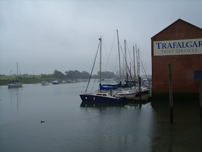
Ready access to the area from the M27 junction 11 or the A27 from Fareham or Gosport. Two practical put-ins, one at the Town Quay where there is a public slip way next to Trafalgar Yacht Services and the second at the head of the creek (shown as a pink 2 on the map. Both points have limited on street parking and access HW+/- 2 Hrs. There is not much water in the creek around low water. It is possible to paddle a short way up up the Wallington River that flows under the roundabout in to the creek, but no more than half a mile to Wallington Village.
Features:
Other than at low water, this is a pleasant creek, home to a small dredger quay and a few yachts. With a golf course on one side and public parks on the other, it can be quite tranquil, except when the wind is in the north / east and the traffic can be heard. There is frequent air activity at Fleetlands (western edge of map). MOD helicopters are serviced here and there are frequent arrivals and departures, which can either be of interest or annoyance depending on your view. Paddling round the coast eastwards to Portchester Castle for a coffee stop, or landing on Pewitt Island can give you a leg stretch. Just up from the slip way at Portchester Castle are public toilets.
Nature:
Home to many visiting wild fowl, Brent and Canada geese are plentiful during the winter months. I have even seen fallow deer roaming the shore line on an early winter morning.
History:
Nothing specific to the creek itself, other than the impresive viaduct at the dead of the creek. Look for the bricked-up arch way that once held the sluice gate for a tide mill that used to exist here. Once out of the creek and looking at Portsmouth Harbour, just another kilometer to the east is Portchester Castle, one of the best preserved roman castles in the UK. The dock yard is ahead in the distance with historic ships.
Waterside Pubs:
Not directly on the water, but within 50 yards of the public slip way at Fareham town quay is the Castle in Air pub.
Hazards:
Only the dredger. Keep an eye open astern.
Subscribe to:
Posts (Atom)
