
View Larger Map
Langstone Harbour entrance SZ 687 990
Chichester Harbour entrance SZ 753 980
Langstone Bridge SU 719 046
In planning a circumnavigation of Hayling Island, a paddler should aim to take advantage of the tides. In the Solent, the tide sets eastwards from two hours before low water, to four hours after, before reversing its direction. On Spring tides, the flow can make a huge difference to passage times. There is slack water around the turn of the tide flow, usually lasting up to an hour. Allow four hours, or more in less than favourable conditions. My route is 15.2 statute miles (13.2 nautical miles). Beware that arriving at Hayling Bridge at low water on spring tides will mean you will be out of the kayak walking through very soft mud.
Langstone Harbour
In my trip, I set off from Tudor Sailing Club in the north west corner of Langstone Harbour, as I happen to be a member. On a flooding tide, an hour after low water, the harbour is reduced to mud, sand and narrow channels. The weather conditions for this trip were ideal, with very light southerly winds and a slight sea. Two of the resident seals greeted me shortly after setting off, but were camera shy. Further down in the harbour entrance, if you tuck yourself in close on either side of the entrance, you can escape the worst of the tide when it is against you. Unfortunately, you can never escape the inevitable jet skis.
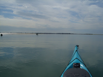

Turing left as you emerge from the harbour, if you have timed it right, you can pass through a very shallow passage, avoiding a long paddle out and around the enormous East Winner sand bank. Be careful in rough weather - my last kayak was holed several times by impromptu groundings here, not by me I hasten to add!
Langstone Harbour to Chichester Harbour ~ Hayling Island Seafront

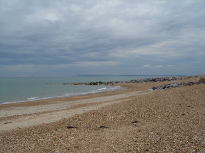
Ahead of you lies 4 miles of shingle beach, the most exposed in the Solent and hence very popular for wind surfers. Not today though. Once past the sand dunes, you paddle parallel to a colourful row of beach huts, atop a sloping sea wall. A white building on the beach comes in to view - a pub called The Inn on the Beach (very original). Next up is an unusual domed tent, marking the fun fair. The beach huts continue, with large houses behind overlooking the sea. Further along, a white square tower comes in view. It is a coast guard look out tower and as you pass it, you realise that it is just the end of a building, the rest being unpainted. The sea wall continues, with many groins jutting out into the sea and more beach front residences behind. You now have only a mile to go before you arrive at the entrance to Chichester Harbour. An odd structure, lying offshore that has been visible for some time, comes clearly into view - the Chichester Bar Beacon. It marks the West Pole Spit that is a similar hazard to the East Winner at Langstone. The sand bar has shifted however so the mark is no longer satisfactory for larger craft. Beware of the tides and difficult seaway that can occur near the harbour entrance.
Chichester Harbour
The harbour mouth, across to East Head.

After a thirty minute break, I was keen to get paddling again. The harbour entrance passed by very quickly, at 6.2 knots in fact...

The view up the Emsworth Channel is typical of much of the Solent - many yachts laying to their moorings. My passage up the eastern side of Hayling Island followed the mud banks, which were still visible. At high water, the small inlets (known as Rythes in Hayling) would provide an amusing hour or so of paddling. The channel continues northward, eventually splitting in two. Emsworth is visible ahead, however to complete the circumnavigation, take the left fork, passing Northney Marina. The channel dries on low water springs. The Hayling Bridge comes in view, with an assortment of buildings on the main land side - Langstone village.


At the right hand end of the buildings, is the foot of an old windmill.
At the left hand end is the Ship Inn public house, accessible directly from the water for about half the tide.
 Langstone Harbour again
 Paddling under the road bridge takes you back in to Langstone Harbour. A small but brisk weir effect can be found at low water springs when the tide begins to rise again. You can just paddle through it. The row of blocks in immediately front of you are the remains of the the Havant to Hayling rail way line, known as the Hayling Billy. Look carefully on the spur of land on the Hayling side. You can still see an old rail signal post. Depending on your start point, you should either follow the channel markers back tot he harbour entrance, or in my case, I picked my way through the small group of RSPB protected islands back to my start point, now with sufficient water in the harbour to make it possible.
The view back across the harbour to Hayling Bridge.


Really useful guide - if visiting Chichester Harbour then take a look at www.conservancy.co.uk
ReplyDeleteReally handy thanks Neil, like you sailed chichester harbour for years but just started Kayaking. A very different harbour in a kayak :-) brilliant though!!! cheers, TomJoy
ReplyDeletecheers neil just had first great paddle around the island. Started at Inn on the Beach aa few hours after low tide and headed east. Beautiful day, though should have waited for outgoing tide before heading from langstone to the ferry, hard paddle against incoming tide. Cheers.Rich
ReplyDeleteSunday 26th October.Bright sunshine - force 5 wind.
ReplyDeleteThanks Neil for the useful tips on starting time with reference to the tides. Two of us started on the Eastney side of the Hayling ferry at low tide. Full force of wind felt on starboard beam at harbour entrance. Used channel inside Winner Bank which just had sufficient depth. Had to keep heads down to avoid kite surfers intent on breaking speed records! Following seas quite demanding so a couple of rests were necessary prior to turning into Chichester Harbour entrance. Exciting and speedy ride in with the ingoing tide. There followed an all too short spell of calmer winds (force 3-4) in the shelter of the west bank until reaching the wide main channel where force 5 winds returned, now directly onto the port beam. Full skeg, edging and sweeping only just kept us in the centre of the main channel(must get fitter). Turned into the wind on the approach to Hayling Bridge and pulled out of the water at The Ship slipway where our back-up team was ready to meet us with the car. First pint hardly touched the sides!
Five hours total time - a very hard paddle in the conditions.
Our last trip around Hayling was much the same as yours Tony - Strong SW wind along Hayling sea front, huge sea. We cleared the sea front in about an hour and as soon as we were in Chichester Harbour entrance, I was thrown in by a breaking wave. We bailed out at The Ship too...
ReplyDeleteHi, good info, I have got a two man inflatable and want to go round the island with my daughter, not too clued up on tides and things, is it best to go anti clockwise ? I was thinking of starting on the seafront as I live close by, I take it I would be best to start as the tide is coming in, go down the chi channel, and back up past the ship, any rough idea how long it would take ? Laine
ReplyDeleteIf I may, with an inflatable I would choose my weather extremely carefully. If you don't like the look of the sea at the seafront, go another day. I would go CLOCKWISE from the seafront. Set off two hours before high tide. The tide will be slack or just going in your favour and will wash you up Langstone Harbour. Pass under the bridge around high tide (don't worry too much if you are a little late. The tide will then carry you down Emsworth Channel to the mouth of Chichester Harbour. It continues to run west for four hours after high tide so should get you back in time. Allow at least six hours which means you might have to fight a bit of tide at some point. I would suggest setting off earlier if you will need more than 6 hours.
ReplyDeleteHi great blog. I've been wanting to circumnavigate the island for a while. I had planned a similar route to the one you've suggested above. My main concern was exiting Chichester harbour with the tide going out. I guess a neap tide is the best time to try it out? Bruce
ReplyDeleteI guess it depends on your start point, but sooner or later you will be fighting the tide. I would aim to be at Chichester Harbour entrance just about highwater if you are going to go clockwise. If you tuck in really close to the Hayling side, you will be out of the worst of it and then get a lift along the sea front. Don't stop or you will be fighting it again at Langstone. Wait until you have got through the entrance before taking a breather as it will only knacker you out if you let the ebb build too much. As you say, do it on neaps....
ReplyDelete